Fort Shepherd Ecological Restoration
Fort Shepherd Conservancy Area restoration on the Columbia River, showing why signs alone failed, how rough and loose trail decommissioning stopped erosion and access, and how native vegetation re-established.
Trail Decommissioning
Rough and loose treatment converted eroded trail corridors to impassable terrain that naturally regenerates.
Columbia River Floodplain
Restoration applied in the ecologically significant Fort Shepherd Conservancy Area on the Columbia River in southeast BC.
Physical Beats Signage
Signage alone did not stop unauthorized access. Physical decommissioning and ecological restoration addressed access and site recovery together.
Fort Shepherd Conservancy Area on the Columbia River had been pushed well away from natural recovery. Off-highway vehicle use, repeated trail disturbance, past grazing pressure, timber impacts, and long fire suppression all contributed to a landscape where some of the normal recovery processes were no longer doing the job on their own.
The restoration sequence was to identify continuing disturbance, address the causes and prepare the ground for native vegetation to return.
Why Recovery Was Stalling
Recovery was limited by several overlapping pressures:
repeated motorized trail use that kept surfaces compacted and bare
concentrated runoff on trail prisms and steep disturbed slopes
ongoing access pressure that prevented seedlings from holding
altered forest structure from decades of suppression and other land-use impacts
In other words, the site could not heal while the disturbance pathway was still functioning.
Signs and Light Controls Were Not Enough
One of the clearest lessons from the presentation is that signage and light access controls are often not enough on heavily impacted trail systems. If the ground surface still functions like a trail, users keep using it. If the trail remains compacted and channelized, it continues to shed water and erode even when traffic drops temporarily.
That is why Fort Shepherd matters as a field example. It moves the discussion past awareness and toward physical ecological repair.
Rough and Loose as Restoration Infrastructure
The main field treatment shown in the deck is rough and loose decommissioning. This is not cosmetic scarification. The objective is to deliberately break the trail prism so it no longer behaves like a road or user-made drainage line.
At Fort Shepherd, rough and loose treatment was used to:
prevent continued motorized access
break compaction and restore infiltration
interrupt concentrated runoff and trail-channel erosion
create topographic heterogeneity and safe sites for native establishment
PES applies rough-and-loose preparation where compacted ground and continued access are limiting restoration.
Early Ecological Response
The presentation documents why the method works. Once the surface is broken up and access is reduced, seedlings and native shrubs establish quickly. Rough and loose ground creates a range of moisture conditions rather than one uniform compacted surface, and that diversity produces more diverse plant establishment.
The aim was to support continuing vegetation establishment and succession.
What This Example Adds to the PES Library
Fort Shepherd is a strong public example because it broadens how people understand soil bioengineering and restoration. It shows that PES methods are not limited to creek banks or engineered slopes. They also apply where degraded access routes, compacted ground, and arrested succession are the main restoration problem.
The treatment logic is still consistent:
remove the ongoing degrading element
rebuild physical site conditions
let native pioneer species re-enter
aim for a functioning ecosystem, not a maintained disturbance corridor
Related Methods and Resources
Takeaway
Fort Shepherd is useful evidence that restoration sometimes starts with making a site physically unusable for the degrading activity that created the problem. Rough and loose treatment does that while also rebuilding infiltration, microsite diversity, and the conditions native vegetation needs to reclaim the ground.
Fort Shepherd: Removing the Filters First
The Fort Shepherd deck shows a restoration sequence that starts with filters, not with a generic treatment. Motorized access, compacted trail prisms, slope erosion, and conifer ingrowth all had to be addressed before natural recovery could take hold again.

Fort Shepherd sits in a dry Columbia River landscape with high ecological value.
Fort Shepherd is a dry Columbia River landscape with riparian edges, open forest and grassland. Trail restoration formed part of a wider ecological restoration program.
The active degrading force was still present. As long as motorized access continued, compacted trails, dust, erosion, and repeated soil disturbance kept resetting the site before vegetation could repair it.

Motorized access was one of the active filters preventing recovery.

Steep disturbed slopes were turning access routes into erosion features.
On steeper ground, the trail becomes a drainage and erosion pathway. This is why passive recovery is weak: the surface is compacted, exposed, and repeatedly disturbed in exactly the places where water and gravity are strongest.
The deck makes an important point for restoration planning: signs can be necessary and still be insufficient. When the landform is already damaged, the surface itself has to be changed so the degrading use cannot continue.

Signs helped communicate the problem, but they were not enough on their own.

Excavator treatment breaks the trail prism and restores roughness.
Rough and loose treatment is the turning point. The excavator breaks the trail prism, pulls in coarse material and woody debris, restores infiltration, and makes the corridor physically unsuitable as an access route.
The finished surface no longer behaves like a road. It has hollows, mounds, roughness, and debris that trap water and seed. That combination removes access pressure and creates safe sites at the same time.

After treatment, the road shape has been converted into rough microsites.

Live-staking results at Fort Shepherd.
The source presentation shows both seedlings establishing on rough-and-loose ground and growth from live staking. These photographs illustrate two complementary ways vegetation can establish after site treatment.
Fort Shepherd also had a forest-structure problem. Fire suppression created dense conifer ingrowth, shifting open dry forest and grassland conditions toward shade, fuel accumulation, and reduced understorey diversity.
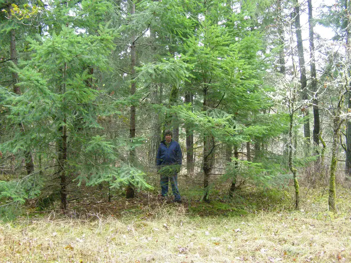
Forest ingrowth was another filter affecting ecosystem structure.

Selective girdling reduced ingrowth while leaving material to decay in place.
Selective girdling is a targeted way to change structure without treating every tree the same way. The treatment aimed to restore the openness and processes needed for recovery.
References
- Source deck: David Polster, Ecological Restoration in the Fort Shepherd Conservancy Area.
- Rough and Loose Surface Treatment
- Succession, Safe Sites, and Pioneering Species
- Filters to Recovery
Learn more
Need a Site-Specific Recommendation?
We can assess the conditions on the ground and match the right living system to your slope, streambank, shoreline, or disturbed site.