VBNWA Floodplain Wetland Restoration
Interior British Columbia · documented restoration 2020–2025 · limited follow-up 2026
Project Overview
Reed canary grass (Phalaris arundinacea) is one of the most persistent and damaging invasive species in BC's interior wetlands and riparian floodplains. A coarse, tall-growing grass originally from Eurasia, it forms dense monocultures that exclude native wetland vegetation, degrade wildlife habitat, and alter hydrology and ecological function. Once established, it is extremely difficult to eradicate because its rhizome network responds aggressively to disturbance.
Restoration across several seasons
- 2020–2021: live-staking work and monitoring, including the 2020 plots described in the 2021 final report.
- 2022–2023: additional planting and live-stake cohorts.
- 2024–2025: shrub infill, establishment care and monitoring.
- August 2026: a limited follow-up site visit noted herbivory, fence damage and maintenance needs.
Work developed across separate planting and monitoring phases. The planting and establishment results below retain their specific monitoring dates.
By 2025, the work had developed into a monitored restoration program focused on dense habitat-building infill, protection from reed canary grass competition, and methods intended to displace the invasive grass over time rather than simply cut it back.
Site Context
The aerial imagery of the site (January 2025) shows the project context clearly: an interior valley floor with a linear irrigation canal running through the center, agricultural fields to the east, a highway on the western margin, and floodplain grassland and wetland areas in between.
The reed canary grass problem is not a one-season weed-control task. Its dense rhizomes and tall growth can suppress planted stock, so the treatment pairs competition control with sustained establishment care and multi-year monitoring.
The project used polygon mapping as the planning framework. Each polygon represents a distinct management unit with its own vegetation condition, treatment logic, and monitoring requirements. In 2025, planting was concentrated within an existing treatment area so new infill could add to the established planting.
VBNWA: reading a restoration program by polygon
Move through the VBNWA field record from valley-floor context to mapped treatment units and a completed-condition reference.
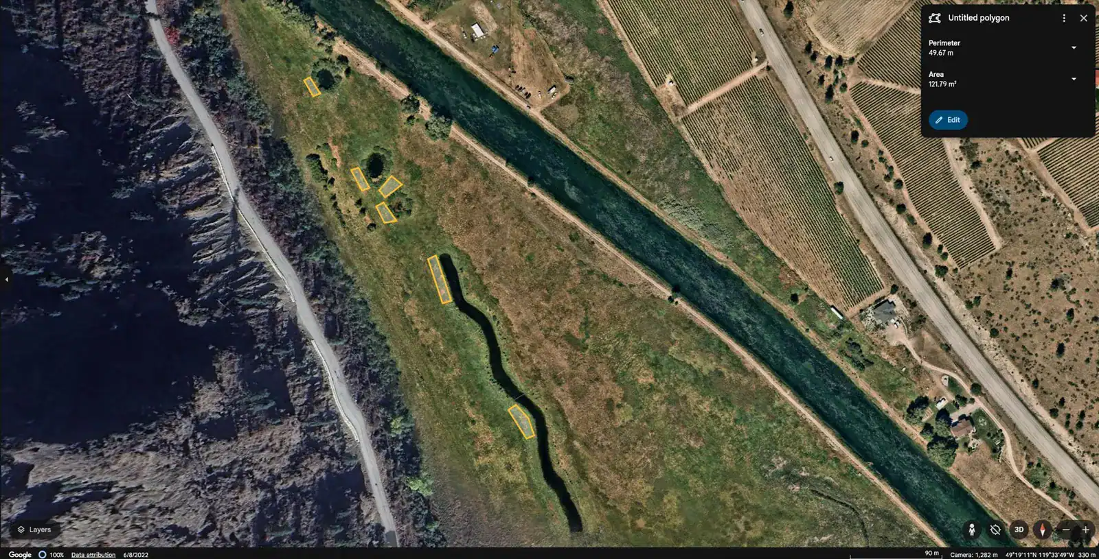 Valley-floor context
January 2025 aerial context shows the wetland valley floor, irrigation canal, agricultural fields, highway edge, and mapped restoration areas.
Source: existing public VBNWA field imagery from the 2024-2025 project phase. These are different mapped units and field views, not a fixed-camera before-and-after comparison. The page's monitoring figures and polygon descriptions remain below.
2025 Planting Scale and Strategy
The 2025 restoration expansion added 672 plants within the intensified polygon. The species mix was deliberately weighted toward dense shrub structure and future riparian tree cover:
- 590 potted nursery plants
- 82 pilot-project plants and live stakes
- heavy emphasis on Nootka rose, prickly rose, and Wood's rose to build dense "rose islands"
- additional black hawthorn, snowberry, black cottonwood, and Saskatoon to expand structural diversity
- 29 potted cottonwoods, 18 potted sandbar willows, and 35 live-stake cottonwoods from the pilot-and-stake program
The planting strategy was aimed at habitat structure, not decorative landscaping. Dense shrubs create nesting and cover conditions; cottonwoods and other woody species create the taller emergent layer needed for perching, song posts, and long-term riparian function.
Field Assessment and Polygon Mapping
The field photography documents the condition of multiple treatment polygons and makes the project methodology legible to crews and partners:
Polygon 1: Dense dried reed canary grass, with field markup showing the exact treatment boundary.
Polygon 2: A second marked treatment area showing the same monoculture problem in an adjacent unit.
Polygon 4: A completed-condition reference polygon showing progress within the broader restoration program.
Ground-level winter condition: Close views of the dried monoculture show how little structural or habitat diversity exists before restoration.
90% First-Year Survival
August 2025 monitoring recorded 558 of 620 Fall 2024 potted shrubs established.
Up to 260 cm
The 2023 sandbar willow live-stake cohort reached calculated heights up to 260 cm.
Critical Establishment Care
Poly weed barriers plus weekly May–September watering supported performance through a hot, dry season.
Reed Canary Grass Management Approach
Effective management of reed canary grass requires understanding the plant's biology. Key points from the PES approach and the literature:
The problem with standard removal: Mechanical removal such as mowing, discing, or tilling often stimulates regrowth by disturbing the soil, which this rhizomatous grass exploits. Surface disturbance alone is usually counter-productive.
Competitive displacement: The durable approach is establishing native species that can compete with, shade, and structurally outgrow reed canary grass over time. Woody native species, including willow, cottonwood, and native shrubs, can progressively displace it through canopy closure and root competition.
Hydrology restoration: In many cases, reed canary grass has benefited from hydrological alterations that dry out what were formerly wetter wetland soils. Where feasible, restoring hydrology (raising water tables, reducing drainage) tips the competitive balance toward native wetland species that are less tolerant of the periodic drying that reed canary grass exploits.
Poly weed-barrier suppression: Poly plastic barriers strongly suppressed reed canary grass around the 2024 potted stock. The monitored cohort achieved 90% first-year survival, with weekly supplemental watering also identified as a critical establishment factor.
Winter planting window: In interior BC, reed canary grass is dormant through the winter months, creating a planting window with lower immediate competition.
Monitoring and maintenance: Multi-year monitoring is essential. Follow-up monitoring should track plant survival, canopy development and reed canary grass competition over successive growing seasons.
Technique Improvements and Habitat Value
The project also tested a useful stock-development method: small cottonwood and sandbar willow cuttings were harvested on site, rooted in pots off site, and then returned to the planting area. That allowed PES to increase the supply of locally sourced woody species where harvestable material was limited.
The planting plan aims to develop dense shrubs and a tree layer for riparian birds and other wildlife, including the yellow-breasted chat, Lewis's woodpecker, and western screech-owl.
Significance
The VBNWA project illustrates several aspects of PES's expertise beyond the core slope bioengineering work:
- Wetland and floodplain restoration grounded in invasive-species biology and native plant community dynamics
- Polygon-based site planning that scales field assessment into contractor-ready restoration units
- Interior BC ecological context with very different species, stressors, and watering realities than coastal shoreline projects
- Long-term habitat strategy focused on structural diversity and wildlife use, not just immediate cover
A female yellow-breasted chat was documented in the treatment area during the 2025 field program. The observation is an encouraging sign of habitat use; continued monitoring is needed to understand how wildlife response develops as the shrub and tree layers mature.
Mapped Polygons and Habitat-Density Strategy
Mapped polygons, dense infill planting, and repeat monitoring make the project logic visible: build structural diversity for riparian habitat while progressively reducing reed canary grass competition.
Aerial context shows the valley-floor wetland, irrigation infrastructure, and treatment layout at project scale.
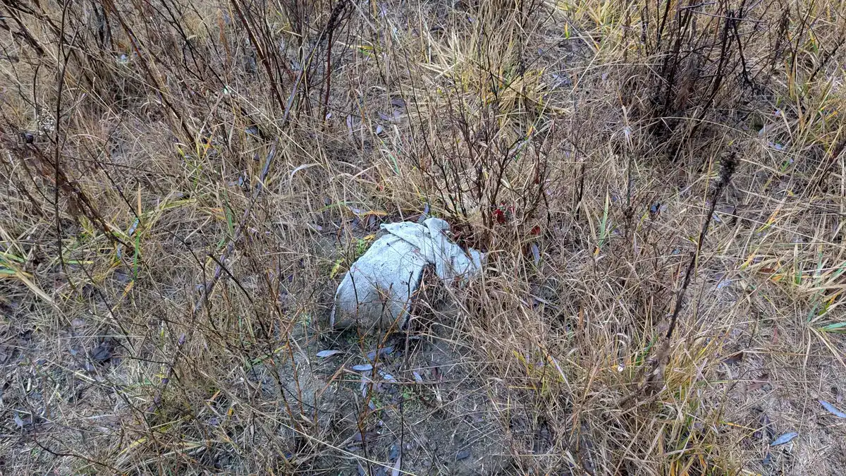
Ground-level winter conditions document the dense reed canary grass cover that restoration planting had to displace.
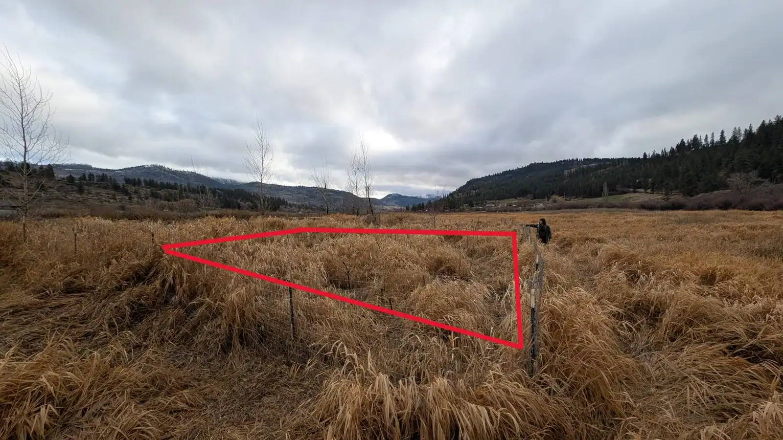
Polygon 1 markup translated field conditions into a practical restoration unit for crews and partners.
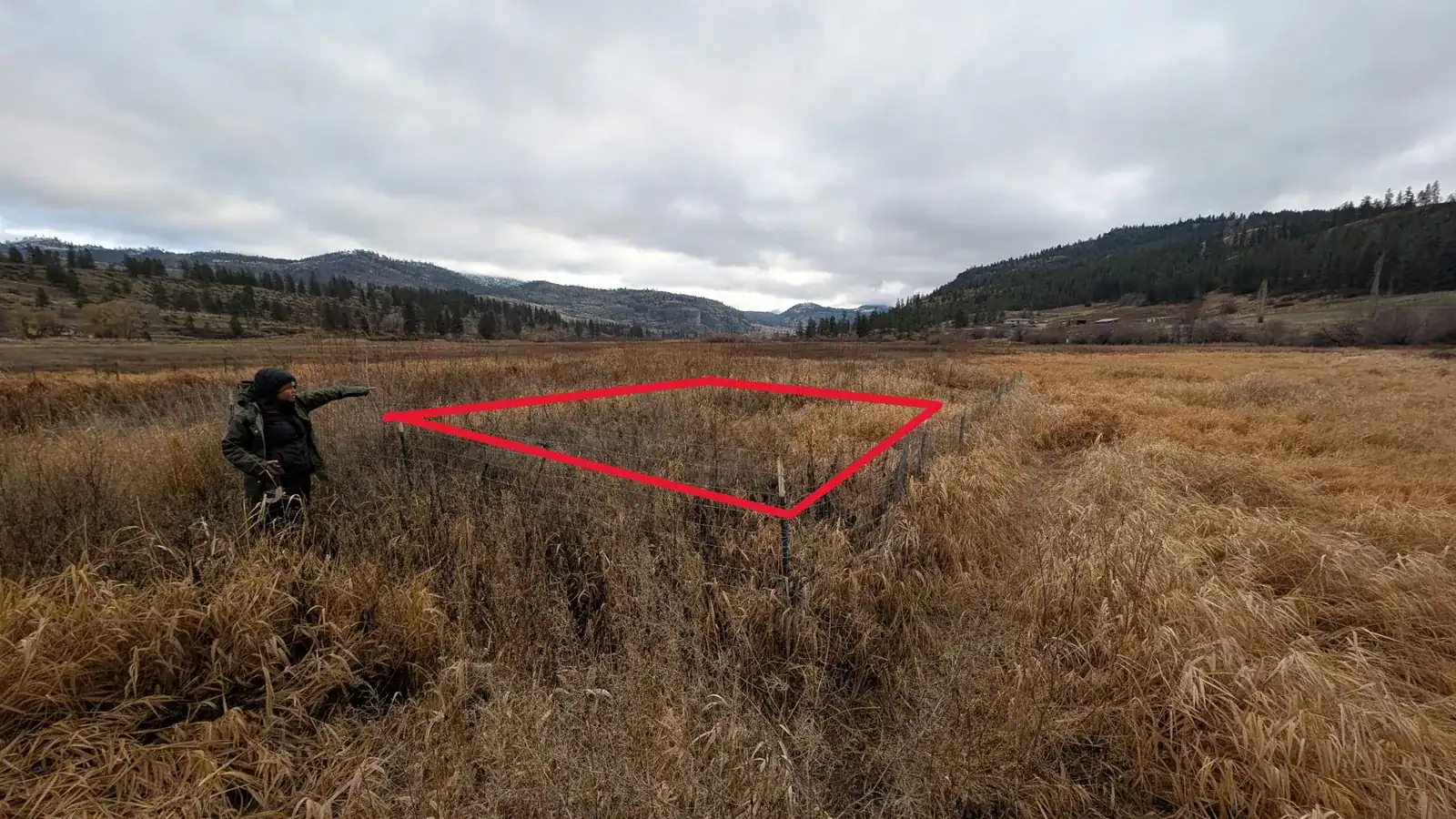
Polygon 2 shows the same mapped-field method carried across adjacent treatment areas.
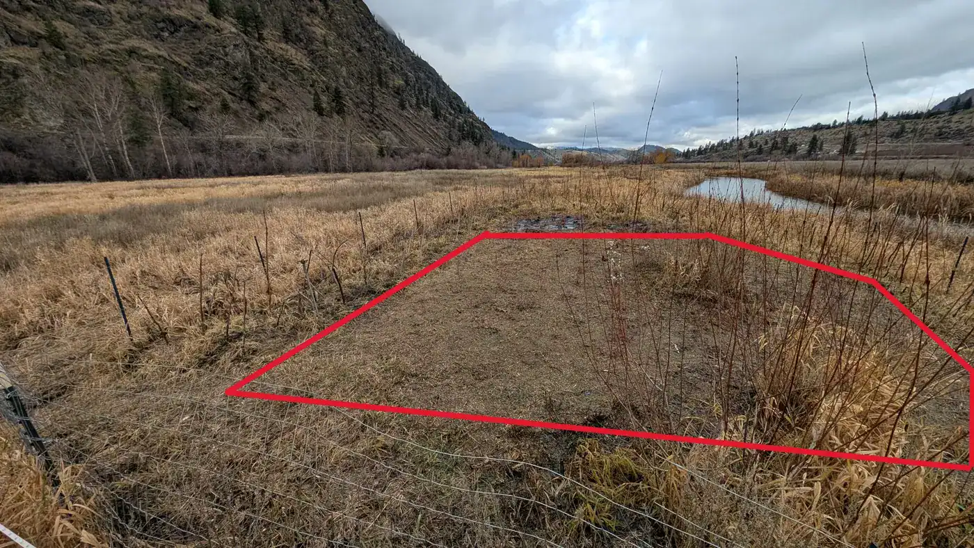
Polygon 4 provides a useful completed-condition reference inside the broader multi-polygon project.
Facing a Similar Challenge?
We can assess hydrology, floodplain connectivity, and revegetation constraints to build a practical wetland restoration sequence.